
Case Study developed by UN Habitat’s Urban Lab.

the planning process in the mountainous regions of khorog, tajikistan
Urban design projects may play a significant role in urban transformations and contribute to wider strategic goals once implemented in a targeted manner. The project “‘Integrated Spatial Plan for Environmental and Socio-Economic Resilience” aimed to improve resilience and social stability for communities in Khorog, Tajikistan is an example of integrated planning that ensured spatial coherence and coordination of various actions at the different scale and across different sectors. The project, carried out by the team of international and local planners, provided environmental, legal, economic, spatial and infrastructure policies and projections, governance and management, recommendations for transformative projects, and planning and technical capacity building for stakeholders to ensure possibilities for their implementation. The project outputs included a detailed assessment, diagnostic and strategic recommendations, analysis and recommendations for legal frameworks and participatory and capacity development components.
Key actors and partners
UN-Habitat has partnered with the Aga Khan Agency for Habitat (AKAH), the government of Tajikistan, through the Aga Khan Development Network (AKDN), to undertake the project activities. The entire planning process involved multiple actors that significantly contributed to all stages of the project from scoping, data collection and assessment to spatial strategy development and validation. UN-Habitat’s Urban Planning and Design Lab (Urban Lab), in a collaborative process with other units and branches within the UN-Habitat Planning Finance and Economy Section and the Urban Practices Branch and with AKAH’s Habitat Planning teams in Geneva and Tajikistan, developed planning directions and practical guidance to improve Khorog resilience and ensure targeted manner and sustainable track of upcoming design interventions. The local government of Khorog and the Region played a critical role in the validation of the project outcomes and in the formulation of the key issues of the city. Local professional societies, representatives from different NGOs and local communities were key stakeholders to validate the project recommendations, provide detailed feedback and support in spatialising local knowledge of the city and define the sites for interventions.
Project Overview
Tajikistan is one of the most vulnerable countries in Central Asia to the impacts of climate change and often experiences floods, earthquakes, and landslides. The impacts of climate change, which is considered as a growing threat to people’s livelihood, are exacerbated by a high level of poverty and unemployment that will be further aggravated by the population growth.
At an elevation of nearly 2,200 meters, Khorog remains one of the highest-altitude peri-urban settlements in Central Asia. At the confluence of the Gunt and Pyanj rivers in Gorno-Badakhshan Autonomous Oblast (GBAO), Khorog serves as the administrative hub and the cultural centre to nearly 240,000 residents in its region.
Despite being the only city/urban area in GBAO and the regional administrative centre, the city is facing multiple challenges such as poor planning, land scarcity and overextended infrastructure that push the expanding population to encroach on habitats that are at significant risk from natural hazards and with limited access to municipal services. This has led to ad hoc interventions in water supply, sewerage and access to energy which has further deteriorated the environment. This, alongside the increasing frequency of natural hazards resulting from climate change, has led to increasing challenges in the maintenance of social stability for the state and civil society.
UN-Habitat and AKAH planning teams developed a comprehensive Integrated Spatial Plan for Environmental and Socio-Economic Resilience, providing technical expertise, drawing on existing methodologies, toolkits, and best practices in a collaborative and integrated way to guide city development. The team used an evidence-based approach to build a database validated on the ground, determine future growth and capacity projections to inform long-term sustainable development in the city, and as an exemplar for the region. Considering the urban context and environmental threats, this initiative will be vital not only to support the current planning process but also for contexts facing similar challenges.
Process Overview
The project consisted of the 3 major parts to ensure an in-depth understanding of the urban form and sound spatial evidence for future design interventions (Fig. 1). The first part “Discovery and Understanding” has been developed in a collaborative process of data collection and desktop research with all the relevant stakeholders to provide a basis of understanding from which the other parts “Diagnosis and Community Engagement” and “Spatial Strategies” were developed. The project structure has been designed to ensure that urban resilience is considered as the fundamental driver of assessment and is integrated throughout all the dimensions of interventions: from strategic recommendations to urban design proposals following the multi-scalar approach (Fig. 2). The spatialization of data and analysis of the city context, conducted through a triangulation of data sources, forecast assessment and diagnosis resulted in the identification of the key six “issues” of the city and strategic “responses”. (the example of issue/response is illustrated on the Fig. 3 and the Fig. 4 respectively).


The identified issues were: 1) urban expansion in the hazard zone, 2) under-used land, 3) fragmented urban fabric, 4) car dependency and lack of pedestrian linkages, 5) Insufficient utility infrastructure and 6) equitable access and efficient use of social facilities.
In response to these issues, the respective strategic recommendations were formulated: 1) growth restriction and hazard mitigation, 2) regeneration & utilisation of under-used areas, 3) creation of mixed-used economic centres & permeability of urban fabric, 4) creation of infrastructure for non-motorized transport & public space network, 5) Improvement of utility infrastructure, 6). Equitable access and efficient use of social facilities
The six strategic recommendations provide a framework from which to develop both strategic-level solutions (Spatial Strategies) and targeted actions (the Action Plan that includes urban design interventions) (Fig. 5). Such methodology helped to define specific areas for interventions - ‘hot spots’ or spatially overlapping different actions that will lead to urban transformations, contributing to the bigger picture – the overall resilience of Khorog.

Fig. 5 Transformation of strategic recommendations into implementable strategies and systematic actions

Fig. 6 Relationship between the proposed eight strategies, six responses, and four urban design recommendations
To catalyse the structural transformation of the city and to showcase how the strategic recommendations and actions can be translated into implementable projects, the key elements of urban design were proposed (Fig. 6). The concepts for urban design proposals were coupled with the analysis of the current implementation mechanisms and informed the development of the new tools (e.g. urban design guidelines) necessary to make implementation possible. The developed proposals for urban design interventions combine the practices of architecture, planning, participatory design, and landscape architecture to increase the functional qualities of the physical environment at a range of scales; from the streetscape, to the pocket park, the block, through to the larger neighbourhood. The examples of such design proposals are illustrated below:
Neighbourhood scale urban design - mixed-use development
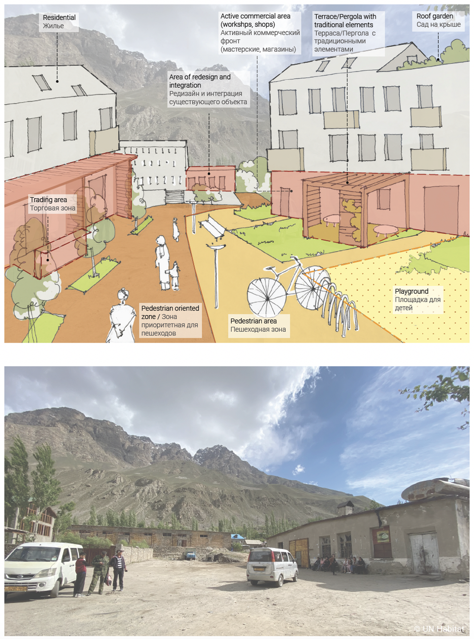
The concepts for design interventions entail the physical application of the UN-Habitat principles for sustainable neighbourhood planning in the context of Khorog, accounting for particular local features. The introduction of these principles to produce more sustainably planned neighbourhoods will significantly contribute to the achievement of the six strategic recommendations. The plots of under-utilised land have been initially selected in the strategic regeneration areas defined as a result of spatial analysis to create compact, integrated and connected neighbourhoods that would provide safe and affordable housing options for people, including those affected by hazards. Figure 7 shows a projected transformation in the area of the former bread factory into a mixed-use neighbourhood with pedestrian orientated infrastructure.
City-wide urban design – streets
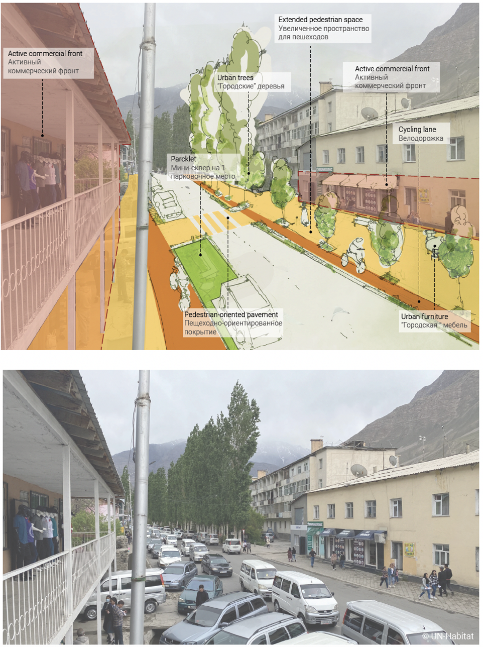
Fig. 8 Ideas for street redesign for the selected route in the central area of Khorog
The Resilient Street Strategy following the strategic responses proposes a set of interventions on street design applied for the selected routes to ensure the major streets of Khorog provide safe, accessible, and healthy travel for all users of the road network, including pedestrians, cyclists, and vehicles. The analysis indicated that the current street network of Khorog can be redesigned without the disrupting or demolishing the existing structural elements. Figure 8 shows the application of the Resilient Street Strategy in the central area of Khorog, demonstrating that the existing capacity of the street is sufficient to accommodate the proposed interventions that are designed to promote non-motorised mobility in Khorog. Greater focus on the redesign of streets and establishment of contemporary guidelines is important as the street network will shape the future urban structure which, in turn, sets the development pattern for blocks, streets, buildings, open spaces and landscapes.
Results
The project became one of the practices, that emphasize the need for evidence-based planning and showcased the practical ways to translate spatial data-based strategic recommendations into urban design projects with the support of participatory process in data collection and validation. The planning process resulted in the continued design and planning initiatives in the city aligned with the integrated spatial plan. In addition, the project methodology informed the preparation of new normative products aimed to build the bridge between the city-wide vision and urban design, which is also necessary to effectively localise the global agendas.
Conclusion
The integration of different scales and themes, participatory component and capacity-building elements provide an enabling environment to develop implementable projects that would demonstrate the positive change on the ground and in meantime impact the overall urbans structure. Policy recommendations for improving urban planning frameworks and development of implementable projects need to be structured through a multi-scalar lens that views the city as a continuum, growing from the neighbourhood to the urban and the broader city-region scale to maximise an impact of design interventions.