
Case Study developed by UNEP’s Cities Unit (2022).

Green and Resilient Areas in Renca, Chile
Photo credits: By © Victor Tabja, courtesy of the Municipalidad de Renca.
The Municipality of Renca, via the Corporación Renca Crece (La Fábrica) and with support of the United Nations Environment Program (UNEP) has led the pilot project: “Green Areas Resilient to Water Scarcity with a Participatory Approach”. Building on the “Integrated Guidelines for Sustainable Neighbourhood Design” (UNEP, 2020), the objective was to strengthen public policies for sustainable urban development in Renca's local government. The intervention aimed to pilot comprehensive solutions to the problems of flooding, lack of green areas, and heatwaves in some key areas. The design and rehabilitation of these pilot areas was developed through a participatory process, led by a local partner UTEM (Universidad Técnica Metropolitana).
Two abandoned spaces were rehabilitated by designing them with nature for rainwater infiltration into aquifers, while taking into consideration the local context to promote a sense of place and integrating other urban needs such as access to connected green public spaces for active transport, access to services and social equality. The intervention generated multiple benefits, such as improving the quality of the neighbourhood, access to shade, the enhancement of nature, the strengthening of security and the sense of belonging and identity with the place.
The project also resulted in recommendations on Municipal planning and management instruments to enable the scaling up and the replication of the approach to other neighbourhoods and cities in Chile and the world.
Key actors and partners
The pilot project “Green Areas Resilient to Water Scarcity with a Participatory Approach” was financed by UNEP and developed by the Municipality of Renca, La Fabrica Corporation and Aguas de Barrio team of the Metropolitan Technological University (UTEM). A number of stakeholders were involved in the implementation:
The main departments of the Municipality (Environment; Public Works; Social Development; Planning; Innovation; Legal; Emergency). They were trained on the UNEP Guidelines and consulted on the pilot projects and recommendations.
The local community. Inhabitants were invited to participate in training and consultation sessions at different stage of the project, including the design of the areas.

Project overview
« Renca […] wants to enjoy its clean, green and safe neighbourhoods, improving the standard of its public spaces through urban renewal […] and through an inclusive and participatory way, with productive sectors that collaborate in said prosperity and with quality, efficient local management with the capacity for innovation. »
Renca is a municipality in Chile that is part of the northwestern suburbs of the capital Santiago. In 2016, its population was 152,399 inhabitants. The area of the municipality is 24 km2 (density of 6,350 inhabitants / km2).
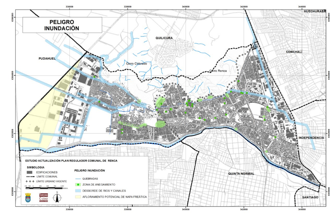
Renca only has 3.5 m2 of accessible green space per capita (Catholic University Center for Public Policies, 2017), which is well below the recommendation of the World Health Organization of 9 m2 of green open space per person (WHO, 2009). Renca presents a high rate of exposure to climatic risks (44.1%), especially those related to heat waves, increased droughts, and climatic events associated with rains that map 36 specific areas of the commune. Progressive waterproofing of the soil has increased the risk of flooding (which is now present on 12% of the communal territory). The impacts of climate change associated with the water scarcity experienced in the commune and the country has driven the need to enhance planning and local capacities of municipal management and citizens, establishing water efficiency criteria for development policies to face the social and environmental challenges of managing the water in the territory.
The project “Green Areas Resilient to Water Scarcity with a Participatory Approach in Renca” aimed to reduce the challenges of water scarcity and risk of waterlogging of streets through an alternative and complementary proposal to the rainwater evacuation systems, while improving pedestrian access for those inhabitants who cannot walk to ‘’plaza units’’.
Process Overview
Understanding the socio-economic challenges and physical planning limitations of Renca, the municipality decided to use green space as an entry point to pilot the guidance provided in the UNEP “Integrated Guidelines for Sustainable Neighbourhood Design”, to serve as a ‘’proof of concept’’ that could be replicated throughout the city. The location of the two pilot areas was also strategically selected in the centre of the municipality.
The pilot project is complementing the ongoing effort of the municipality to increase the livability and sustainability of the 27 neighbourhoods around the Balmaceda axis and the Manuel Rodrigues axis, including with actions related to sustainable mobility, access to health centres, community garden, creation of parks, etc.
The goal of the project was to develop two green pilot areas that would improve soil absorption capacity, through the design and construction of Sustainable Urban Drainage Systems (SUDS), while at the same time increase access to squares through improvement in pedestrian connection and access to services and public electric transport. The project aimed also aimed at enriching the public space by landscaping with local identity, adding social, ecological and environmental values to its design.
The project included a strong participatory component and the community was engaged at the 3 main stages of the project:
Capacity building in the preparation phase;
Participatory design or co-ecodesign of the green areas;
Evaluation and preparation of recommendations.
The project also presented a strong component of environmental education, for which the University UTEM provided two training sessions: Green Infrastructure and Drainage properties of the different soil layers.
Three design prototypes were created for the two selected areas. The neighbours chose the final two designs according to the attributes they had previously chosen as key indicators: safety of spaces, green areas with durable plants and trees that provide shade, spaces the elderly could use as a place of transit and rest, interlinks to community services such as public electric transport, free fair, the community pharmacy, and the friendly health centre. The two selected squares (plazas) were named Jardín Central (central garden) and Sendero Vergara (Vergara Path). The neighbours also selected the species to be planted among a set of proposed alternatives of native and adapted trees and flora (types of grasses, shrubs and flowers), that could serve as water infiltrators in the flooding areas.
Results
The two green areas have now been built and are starting to be used. With the “Integrated Guidelines for Sustainable Neighbourhood Design” in mind, a set of recommendations for the way forward were jointly developed by the partners involved in the project. These include:
Address the continuity strategy of the project of buffer areas resilient to water scarcity according to the Renca climate risks and flooding maps.
Integrate the pilot strategy to other walkable biodiversity corridors interconnected with parks, urban gardens, the road to the hill.
Establish in the 2022 and future Planning of the commune, a network of these areas interconnected to other green and blue public infrastructure in the neighbourhood and scale up to commune level.
Integrate the network to nodes of electric public transport, bike lines, nodes of local commerce, jobs, schools, health centres and other services.
Enable unused spaces on or under highways to generate quality spaces and revitalize them.
Incorporate Quality Programs, Master Plans, Adapt Design Codes towards sustainability, including sustainable stands for local public spaces, in terms of materials used, applying local landscapes, etc.
Use the Voluntary offsetting mechanism of private development projects policy to incentivize nature-based solutions.


Conclusion: The Integrated Approach
The “Green Areas Resilient to Water Scarcity with a Participatory Approach” project was selected as a priority focus in order to demonstrate how an integrated approach can be adopted for small scale developments while bringing important benefits to the neighbours. They showcase that it was possible to achieve multiple benefits at local level, including:
Providing comprehensive solutions to problems identified in the community: flood zones, lack of green areas, heat wave.
Adaptation to climate change impacts, specifically water scarcity.
Enhancing ecosystem services through increased soil absorption, recharge of groundwater and preserved biodiversity.
Providing evidence and visualizing the virtuous relationship and synergy between governance, participation and urban design.
Integrating design allowing to increase the diversity of uses of the spaces (connectivity, recreation, education, culture, environmental benefits, etc.).
High appreciation for the design, its contribution to the landscape and improvement of the quality of the neighborhood and wellbeing of the population.
Improving security, regenerating of lost public spaces for community gathering, with access to shades and accommodates for the elderly.
Promoting or triggering other initiatives in a synergistic way, for example 15 connected green and blue public spaces for active transport and connection to commerce and services.
Strengthening the sense of belonging and identity with the place.